Research Outcomes
The 'Mapping the Lakes' pilot project has opened up new ways of thinking about the potential use of GIS technology in literary studies. Below we have used a series of sub-headings to list some of the key research outcomes of the pilot project.
Texts & Textuality
- The process of digitising the primary texts involved typing up, and tagging, the respective accounts by Gray and Coleridge: a process which proved to be extremely time-consuming. Future literary GIS projects, will require the development of an alternative method of textual digitisation and encoding.
- Connected with this, the researcher will need to be able to draw upon a greater range of spatial attributes with which to tag the 'data' (in other words, the primary texts). In this pilot project, each place name was given one of three attributes based upon the supposed actuality of writerly spatial experience: 'visited'; 'unvisited'; or 'unknown'. The future literary GIS, however, will need to offer a way of representing the imagined, as well as the actual, experience of place.
- For the benefit of this pilot project, we (erroneously) followed Roger Hudson's editorial strategy of bringing together text - from Coleridge's Notebooks and his letters to Sara Hutchinson - to create a composite version of his 1802 tour of the Lake District. This strategy may facilitate the process of mapping the writer's movement through the landscape but it leads to an unnecessary simplification of the complex textuality of Coleridge's account. For example, the creation of this composite account fails to acknowledge that intertextual references made in Coleridge's Notebooks (to Thomas West and William Gilpin; or to Salvator Rosa) do not feature in his letters to Sara Hutchinson. The geo-specificity of these explicit references highlights how Coleridge perceives particular locations as sites of spatial intertetxuality. At the same time, such discrepancies raise important questions regarding the ways in which Coleridge's articulation of his geographical experience differs across textual forms and spaces. A more comprehensive project would have to remain sensitive to these textual overlaps and intersections: all texts (both Notebooks and letters) would have to be digitised in their entirety; and separate maps would have to be created from each textual source, thereby offering the user the potential for cartographical layering and comparison.
- Finally, to facilitate the digitising, and tagging, of the primary texts, it was often necessary to modernise/clarify spellings. This practice of textual amendment is inherently problematic. Future literary GIS projects will need to address questions of textuality at the beginning of the digitising process; the practices of text encoding, geo-referencing and map-making must be afforded equal attention and emphasis.
Maps & Mapping
- The use of the Digimap Gazetteer presented a few geo-referencing problems. Most significantly, the database offers the user several pairs of geographical co-ordinates for rivers: in this particular instance, the Gazetteer provided several geo-references for the River Eden in the north of the county of Cumbria. These spatial anomalies can be filtered out manually as the researcher can identify the pair of co-ordinates which most closely matches the route mapped out in the primary text. Is it possible, though, to develop a more effective method of geo-referencing which automatically deals with these kinds of spatial error?
- The use of straight lines to connect two points on a map can lead to a misleading visualisation of the textual representation of spatial experience. That is to say, the straight line methodology fails to represent the particularised geo-specific movements recorded by writers in their textual accounts of place. How can a literary GIS, then, represent the ways in which a writer articulates his or her movements through a particular topography? How can GIS technology map out specific, non-linear, routes through space? Is it possible that the answers lie with GPS technology? The use of a hand-held geo-referencing device may allow the researcher to digitise a writer's movements by retracing (as accurately as possible) his or her route through a particular territory.
- The writerly documentation of landscape and environment is predicated on the oscillation between different, yet overlapping, geographical scales. In other words, writers document the movement between sweeping prospects and microscopic attention to detail which characterises everday spatial experience. But the question remains as to how GIS technology can be used to map out these constant shifts in scales and perspectives. How can digital maps be used to illustrate, for instance, the way in which a writer may move between ideas and images of the local, the regional, the national and even the international? What is needed is a form of digital map-making which allows the user to toggle between what may be described as micro- and macro-cartographies. By moving between, and overlaying, these different representations of space, the user may be able to visualise the different cartographical perspectives which underpin the textual documentation of place.
- The literary critic needs to produce digital maps which open up, rather than close down, the imaginative spatialities embedded in geo-specific texts. As a result, perhaps the future of the literary GIS will depend on a movement towards the more exploratory qualitative mappings some contemporary artists have begun to undertake rather than the quantitative cartographies traditionally associated with historical GIS projects. Writing in his anthology, 'Mappings', the geographer, Denis Cosgrove, suggests that: 'The most challenging mappings today are found in the creative and imaginative work of artists, architects and designers, neither seeking absolute empirical warranty for their maps nor claiming for them any metaphysical revelation' (p. 19). The self-reflexive nature of these contemporary artistic practices similarly needs to underpin the work of the cartographical critic.
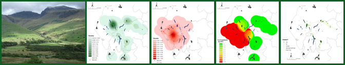
- As part of the pilot project, a density smoothing technique has been applied to the historical movement of the writer through space. That is to say, smooth surface technology has been used to map out what could be described as 'hard' data. There is an argument, however, that this particular use of density smoothing techniques can lead to a misleading mapping: a close reading of the primary texts can result in the production of a more precise historical GIS than this cartographical representation suggests. The use of this density smoothing methodology corresponds with the spatial preoccupations of 'fuzzy geographers': researchers who are interested in the overlapping of actual geographies and the more vague notions of space which characterise the quotidian experience of being-in-the-world (in Lefebvrean terms, researchers who are interested in the intersections of 'spatial practice', 'representations of space' and 'representational spaces'). As a result, this smooth surface form of mapping may be of greater use when applied to more abstract or imaginative readings of geo-specific texts; the cartographical imprecision of this type of GIS coincides with what is often the geographical inaccuracies or vagueness of both writerly productions and readerly interpretations of geo-specific texts.
Conceptual Possibilities
- The pilot project is underpinned by the belief that the use of GIS technology may facilitate further thinking about the complex relationships between time, place and texts. The creation of exploratory digital maps may facilitate the conceptual understanding of the intertextuality of space. The theoretical possibilities opened up by the use of GIS technology are predicated, at least in part, upon the collation, digitisation and cartographical visualisation of significant amounts of data. To be more specific, the creation of a Lake District literary GIS requires the representation of a complex cultural history which ranges from the geo-specific guide books of the Picturesque movement to the reimaginings of place offered in modern film and television accounts of the Lakes. What is more, the GIS needs to represent the intersections of, or tensions between, these imaginative representations of place and official configurations of regional space: the GIS needs to offer a layering of what Lefebvre calls 'representational spaces' (the 'essentially qualitative, fluid and dynamic' experience of space which forms the foundations for artistic accounts of everydayness) and 'representations of space' (including the 'conceived' spaces of administrative boundaries).
- More work also needs to be carried out on the way in which the computer screen offers a fluid and interactive digital space for the bringing togethe r of electronic texts, GIS mappings and critical commentary. The creation of a literary GIS provides an opportunity for exploring the spatial content of texts. Alongside this, it offers the potential for reflecting upon what Mark Nunes labels, in 'Cyberspaces of Everyday Life', 'the topographies of the world wide web' (p. 1). As a result, the production of a literary GIS invites the critic to engage with a range of imbricated spatialities.
- A literary GIS needs to create 'mood maps': cartographies which represent the geo-specificity of articulated emotional responses to environment. Alongside this, the GIS needs to produce 'memory maps'. That is to say, the GIS should map out the locations at which writers reflect upon earlier spatial experiences; at the same time, it should map out those sites at which writers look forward to future encounters with place. A literary GIS, then, needs to set up cartographies of writerly retrospection and anticipation. The role of the spatial critic will be to explore the webs, networks, patterns and intersices which are highlighted by the mapping of temporally-fluid accounts of landscape and environment.
- GIS opens up the technological space for exploring both writerly and readerly spatialities. Through the processes of textual digitisation, and digital map-making, the critic can identify, visualise and explore the ways in which cartographical ideas and practices inform a writer's response to place. It is an approach which leads to the casting of the writer as map-maker. At the same time, the spatial critic can use GIS as an interpretative tool: he or she can create maps to open up subjective readings of geo-specific texts. Connected with this, a literary GIS website could also incorporate an element of user interaction: a facility could be developed which would allow users to map out their own spatial readings of literary texts. Ultimately, then, the construction of a literary GIS may also feed off, and back into, reader-response theory: it may facilitate further thinking about the ways in which a range of readers engage with the geo-specific literature of place and space.
Pedagogical Possibilities
- In the early stages of the process, the 'Mapping the Lakes' project website was primarily conceived as a space in which to present the GIS maps and in which to disseminate the research findings of the pilot scheme. Increasingly, we have also become alert to the pedagogical possibilities opened up by the use of digital space. The project website has the potential to serve as a teaching tool in a range of interrelated areas: the Picturesque movement and British Romanticism; the spatial history of the English Lake District; theories of place and space, landscape and environment; and, of course, the relationship between literature and cartography. The process of digitisation also raises crucial questions regarding electronic textuality and editorial responsibility. As a result, an awareness of multi-layered usership will have to be embedded in the development of future sites.